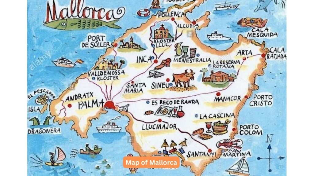
Understanding the map of Mallorca is essential for navigating this stunning Mediterranean island. As the largest gem in Spain’s Balearic archipelago, Mallorca’s diverse geography and rich cultural tapestry reveal themselves through its intricate cartographic representation. When you examine a detailed map of Mallorca, you’ll discover a unique blend of dramatic mountains, pristine coastlines, and charming villages that make this destination truly extraordinary. Whether you’re planning your first visit or seeking to deepen your knowledge of the island’s layout, this comprehensive map of Mallorca guide will help you master every contour, valley, and coastline that defines this Mediterranean paradise.
Geographical Overview of Mallorca’s Location and Shape
Mallorca sits proudly in the western Mediterranean Sea, forming the crown jewel of the Balearic Islands collection. The island’s distinctive diamond shape spans approximately 100 kilometers from east to west and 75 kilometers from north to south, creating a landmass that covers 3,640 square kilometers.
The map of Mallorca reveals several key geographical characteristics:
- Central Mountain Range: The dramatic Serra de Tramuntana dominates the northwestern portion, creating a spine that defines the island’s climate and character.
- Coastal Variations: The northern coastline features dramatic cliffs and hidden coves, while the south presents gentler slopes and expansive beaches.
- Fertile Plains: The central region, known as Es Pla, showcases Mallorca’s agricultural heartland with golden wheat fields and traditional villages.
- Strategic Position: Located 170 kilometers from the Spanish mainland and 300 kilometers from Algeria, Mallorca’s map position has historically influenced its cultural development.
Main Regions on the Map of Mallorca
The island’s cartographic layout naturally divides into distinct regions, each showcasing unique characteristics that make a map of Mallorca essential for exploration planning. Understanding these regional boundaries enhances navigation and enriches your travel experience.
The island’s five primary regions appear clearly on any detailed mallorca map:
- Palma Region: Centered around the capital city, this area encompasses the Bay of Palma and represents the island’s commercial and cultural hub, holding nearly half of Mallorca’s population.
- Northern Region: Characterized by dramatic mountains and rugged coastline, this area includes popular destinations like Pollença and Alcúdia, along with the stunning Cap de Formentor peninsula.
- Eastern Region: Home to coastal resorts like Cala Millor and natural wonders like the Caves of Drach, this region features gentle hills and numerous beaches.
- Southern Region: The quieter side of Mallorca includes picturesque villages like Santanyí and pristine beaches such as Es Trenc.
- Western Region: Dominated by the Tramuntana mountains, this UNESCO World Heritage area features traditional villages like Deià and Valldemossa.
Major Cities and Towns on the Mallorca Map
Reading any map of Mallorca reveals a fascinating network of urban centers, from the bustling capital to charming mountain villages. Each settlement has evolved according to its geographical context and historical significance.
Metropolitan Areas
Key urban areas clearly marked on any reliable mallorca map include:
- Palma de Mallorca: The capital city dominates the southwest coast, featuring the iconic La Seu Cathedral, extensive port facilities, and radiating road networks that connect to every corner of the island.
- Calviá: Including the famous resort areas of Magaluf and Santa Ponça, this municipality represents one of Europe’s premier tourist destinations.
- Manacor: The island’s second-largest city, known for pearl manufacturing and as the birthplace of tennis legend Rafael Nadal, sits in the eastern agricultural region.
Historic Towns
Traditional settlements that have preserved their authentic character appear on cultural maps:
- Alcúdia: This historic walled town in the north features Roman ruins and serves as a gateway to the stunning Bay of Alcúdia.
- Sóller: Nestled in a mountain valley accessible by historic train, this citrus-growing town exemplifies traditional Mallorcan architecture.
- Pollença: A charming town at the foot of Puig de Pollença, famous for its Sunday market and artistic heritage.
Prominent Geographical Features
Reading any map of Mallorca reveals the island’s dramatic topographical diversity, from soaring peaks to mysterious caves. These features define the island’s character and influence travel routes significantly.
Notable geographical landmarks include:
- Serra de Tramuntana: This UNESCO-protected mountain range stretches 90 kilometers along the northwest coast, with Puig Major reaching 1,445 meters as the island’s highest point.
- Cap de Formentor: Known as the “meeting point of the winds,” this dramatic peninsula extends northward like a finger pointing into the Mediterranean.
- Mondragó Natural Park: Visible on any balearic islands map, this protected area in the southeast showcases pristine beaches and Mediterranean woodland.
- Cabrera Archipelago: Although separate from the main island, this national park appears on comprehensive mallorca maps as an important protected marine reserve.
- Son Serra de Marina Wetlands: These coastal wetlands in the northeast represent important bird habitats and appear on specialized nature maps.
Airports and Entry Points
Understanding entry points on the map of Mallorca is crucial for travel planning. The island’s connectivity shapes visitor movements and regional development patterns significantly.
Main access points clearly marked on mallorca transportation maps:
- Palma Airport (Son Sant Joan): Located 8 kilometers east of Palma, this international airport appears prominently on all maps as the primary gateway for over 75% of visitors.
- Port of Palma: The largest port in the Balearics handles cruise ships and ferries, with its distinctive shape easily identifiable on coastal maps.
- Alcúdia Port: This northern port connects Mallorca to Menorca and the Spanish mainland, appearing on ferry route maps.
- Major Marinas: Numerous smaller ports and marinas dot the coastline, each marked on nautical charts and tourist maps.
Road Network and Main Transportation Routes
The map of Mallorca reveals an efficient road network radiating from Palma like spokes on a wheel. Understanding this transportation infrastructure helps travelers navigate the island efficiently and plan optimal routes.
Key transportation features on any majorca map include:
- Ma-1 Motorway: This primary route circumnavigates the island’s coast, connecting major tourist areas and appearing on all road maps as a thick line.
- Ma-13 Highway: Running northeast from Palma through the center, this route provides the fastest connection to northern destinations.
- Mountain Roads: The Ma-10 scenic route through the Tramuntana mountains appears as a winding line on topographical maps, famous for its hairpin bends.
- Secondary Roads: A network of smaller roads connects interior villages, often following historical routes that respect the island’s topography.
- Railway Lines: The limited rail network includes the popular tourist train from Palma to Sóller, marked distinctively on transportation maps.
Natural Reserves and National Parks
Protected areas feature prominently on environmental maps of Mallorca, highlighting the island’s commitment to conservation. These zones often restrict development and preserve unique ecosystems that make the island special.
Important protected areas visible on detailed mallorca maps:
- Sa Dragonera Nature Park: This uninhabited island off the southwest coast appears on most maps as a protected bird sanctuary.
- Albufera Natural Park: The island’s largest wetland system in the north shows clearly on topographical maps with its distinctive lagoon features.
- Llevant Peninsula Nature Park: This rugged eastern headland features hiking trails and pristine coastline, marked on recreational maps.
- Sierra de Levante Regional Reserve: Covering the eastern mountain range, this protected area appears on conservation and hiking maps.
- Marine Protected Areas: Various coastal zones have special protection status, marked on nautical charts and environmental maps.
Tips for Using Your Map of Mallorca
Effectively reading and using a map of Mallorca requires understanding local conventions and geographical context. Both traditional paper maps and digital versions offer unique advantages for navigation and exploration.
Essential Navigation Strategies
Essential map reading strategies for Mallorca include:
- Scale Understanding: Most tourist maps use scales between 1: 200,000 and 1: 500,000, enabling overview planning while detail maps show smaller areas at 1: 50,000 or larger.
- Legend Familiarity: Spanish and Catalan language abbreviations appear frequently, with “Cala” meaning cove, “Cap” meaning cape, and “Serra” meaning mountain range.
- Contour Interpretation: The dramatic elevation changes, especially in the Tramuntana region, require attention to contour lines for accurate travel time estimation.
Digital Integration
Modern navigation methods complement traditional reading of a map of Mallorca:
- Digital Integration: Modern apps complement physical maps but require cellular coverage or downloaded offline maps for reliable navigation.
- Seasonal Considerations: Some mountain roads may be marked as seasonal routes, closed during winter months for safety reasons.
- GPS Supplements: While digital navigation helps, keeping a paper map backup proves valuable in areas with limited mobile coverage.

Historical and Cultural Context
The map of Mallorca tells a story of centuries of human settlement and natural evolution. Understanding this context enriches any exploration of the island’s geography and enhances your appreciation.
Cultural elements visible on detailed maps:
- UNESCO World Heritage Sites: The Tramuntana mountains and Palma’s historic center appear with special markings on cultural heritage maps.
- Archaeological Sites: Ancient Talayotic settlements marked with symbols showing Mallorca’s prehistoric past.
- Traditional Architecture: Stone wall patterns (marges) appear on detailed maps, showing the historical agricultural landscape.
- Religious Heritage: The distribution of monasteries and churches reflects pilgrimage routes and historical religious importance.
- Maritime History: Watchtowers along the coast appear on historical maps, revealing defensive strategies against pirates.
Practical Navigation Tips
Successfully navigating Mallorca requires more than just reading coordinates. Local knowledge and practical considerations enhance the map-reading experience for travelers exploring this beautiful island.
Key navigation advice for using mallorca maps:
- Distance Reality: Mountain routes may look short on maps but require significantly more travel time than coastal roads of similar distance.
- Parking Awareness: Historic town centers often have limited vehicle access, requiring advance planning using detailed city maps.
- Beach Access: Some beautiful coves marked on maps require hiking or 4×4 vehicles to reach, not always obvious from simple tourist maps.
- Alternate Routes: Having backup routes planned helps during peak tourist season when main roads become congested.
- Map Updates: Always verify road conditions and closures, especially in mountain areas where constructions or weather can affect accessibility.
Seasonal Map Considerations
The map of Mallorca transforms throughout the year, with different features becoming more or less accessible depending on the season. Understanding these variations helps in trip planning and ensures optimal experiences.
Seasonal factors affecting map usage include:
- Summer Crowds: Tourist areas marked on maps experience peak congestion between July and August, affecting travel times significantly.
- Winter Closures: Some mountain passes and scenic routes may be temporarily impassable, requiring alternate route planning.
- Weather Impact: Coastal maps need interpretation based on wind direction and seasonal storms that can affect ferry schedules and beach accessibility.
- Event Calendars: Major festivals and markets appear on specialized maps, influencing traffic patterns and accommodation availability.
- Natural Phenomena: Seasonal bird migrations affect protected areas marked on environmental maps, with some zones having restricted access.
Regional Deep Dive: Palma de Mallorca
The capital city deserves special attention when studying any map of Mallorca. Palma’s layout reflects its historical development from Roman times through Moorish rule to the present day, creating a fascinating urban tapestry.
Historic Quarter
Key features in Palma city maps include:
- Historic Quarter: The maze-like old town centers on the Cathedral, with narrow streets requiring specialized pedestrian maps for navigation.
- Bay Configuration: The famous Palma Bay creates a natural amphitheater effect, influencing the city’s development patterns visible on aerial maps.
- Industrial Areas: Port facilities and industrial zones appear clearly marked, helping travelers avoid congested areas during business hours.
Green Spaces and Transportation
Urban planning elements visible on detailed maps:
- Green Spaces: Parks like Bellver with its unique circular castle show as distinct green areas on city maps.
- Transportation Hubs: The train station, bus terminals, and metro stops form crucial reference points for navigation within the city.
- Tourist Zones: Clearly marked areas help distinguish between residential neighborhoods and tourist-oriented districts.
Mountain Region Mapping
The Serra de Tramuntana presents unique cartographic challenges due to its dramatic topography. Specialized hiking and climbing maps reveal details invisible on standard tourist maps of Mallorca.
Important features in mountain region maps:
- Elevation Profiles: Detailed contour lines show the dramatic elevation changes, essential for hikers and cyclists planning routes.
- Trail Networks: Historic pilgrimage routes and modern hiking paths criss-cross the mountains, requiring specialized topographical maps.
- GR-221 Route: This long-distance hiking trail appears on dedicated hiking maps, showing refuges and water sources.
- Scenic Viewpoints: Famous lookout points like Na Foradada and Mirador de ses Barques are marked for photographers and sightseers.
- Village Connections: Remote villages accessible only by narrow mountain roads appear with special symbols indicating road conditions.
Coastal Features and Beach Access
Mallorca’s extensive coastline features prominently on all maps, with different types highlighting various aspects of the coastal geography. Understanding beach access requires careful map interpretation for optimal experiences.
Beach Categories
Coastal mapping details include:
- Beach Categories: Maps distinguish between sandy beaches, rocky coves, and pebble shores using different symbols and colors.
- Access Routes: Footpaths to remote beaches often appear as dotted lines, indicating informal or unmaintained access.
- Anchorage Spots: Nautical charts show safe anchoring areas and underwater hazards crucial for boaters.
Natural Formations
Geological features marked on coastal maps:
- Cliff Formations: Dramatic coastal cliffs appear with special markings, often indicating photo opportunities or climbing locations.
- Marine Features: Underwater caves and reefs visible on specialized maps attract divers and snorkelers.
- Protected Coves: Special designations mark ecologically sensitive areas with restricted access or activities.
Agricultural Landscape
The central plains of Mallorca, visible on any agricultural map, showcase the island’s productive farming heritage. Understanding this rural landscape adds depth to travel experiences beyond typical tourist spots.
Agricultural features on mallorca maps:
- Irrigation Systems: Ancient windmills and modern irrigation channels appear on detailed regional maps.
- Wine Regions: Designated wine-growing areas in the Binissalem and Pla i Llevant regions show with special agricultural symbols.
- Olive Groves: Historical olive production areas, some dating back over 1,000 years, appear on cultural and agricultural maps.
- Almond Orchards: The spectacular almond blossom routes in February are marked on seasonal tourist maps.
- Crop Rotation Patterns: Modern satellite imagery and agricultural maps show the changing patterns of land use throughout the seasons.
Island Circumnavigation Planning
Planning a complete circuit of Mallorca requires understanding the various route options visible on comprehensive island maps. This journey reveals the full diversity of the island’s geography and cultural heritage.
Route Options
Circumnavigation considerations include:
- Coastal Route Options: Multiple paths exist for touring the perimeter, from highways to scenic secondary roads marked differently on maps.
- Interior Shortcuts: Cross-island routes offer alternatives during peak tourist seasons, avoiding congested coastal areas.
- Ferry Connections: Island-hopping possibilities to Ibiza, Menorca, and the mainland appear on ferry route maps.
Specialized Tours
Different travel styles require different mapping approaches:
- Cycling Routes: Dedicated cycling maps show bike-friendly roads and challenging mountain passes popular with enthusiasts.
- Natural Barriers: Mountain ranges and protected areas influence possible route choices, requiring careful planning with topographical maps.
- Cultural Routes: Themed itineraries combining historical sites, museums, and traditional villages appear on cultural tourism maps.
Digital Mapping Resources
Modern travelers benefit from various digital mapping tools that complement traditional paper maps of Mallorca. Understanding these resources enhances navigation and exploration planning significantly.
Available Digital Options
Available digital mapping options:
- OpenStreetMap: This freely editable map provides detailed coverage of Mallorca with user-contributed points of interest.
- Google Maps: Excellent for urban navigation and general travel planning, with real-time traffic updates in major areas.
- Specialized Apps: Wikiloc for hiking trails, Komoot for cycling routes, and Navionics for marine navigation offer detailed regional data.
Offline Capabilities
Essential digital considerations:
- Official Tourism Maps: The Mallorca tourism board provides downloadable PDF maps with current tourist information.
- Offline Capabilities: Downloaded map data ensures navigation continues in areas with poor mobile coverage.
- Integration Benefits: Combining digital and paper maps provides the most reliable navigation experience.
Historical Maps and Evolution
Understanding how the map of Mallorca has evolved over centuries provides context for current geographical features. Historical cartography reveals the island’s changing landscape and human impact through time.
Historical mapping insights include:
- Ancient Trade Routes: Roman roads still influence modern highway placement, visible in the direct routes between major towns.
- Moorish Influence: The irrigation systems designed during Moorish rule appear on agricultural maps, still functional today.
- Coastal Changes: Historical shoreline variations show how beaches have evolved and developed over time.
- Cartographic Accuracy: The progression from rough medieval sketches to precise satellite imagery demonstrates mapping technology advancement.
- Cultural Preservation: Maps showing traditional stone walls and terraces help protect agricultural heritage sites.

Mastering the map of Mallorca opens doors to deeper appreciation of this Mediterranean jewel. Whether planning mountain adventures, coastal explorations, or cultural discoveries, understanding the island’s cartographic representation enhances every journey through this paradise. The diverse geography, from dramatic cliffs to fertile plains, creates a tapestry of experiences that maps help unravel for travelers seeking authentic Spanish island experiences. By combining traditional navigation skills with modern digital tools and local knowledge, visitors can fully appreciate the complexity and beauty that makes Mallorca one of the Mediterranean’s most captivating destinations.


