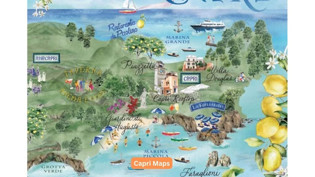
Introduction: Understanding Capri’s Unique Geography
The mesmerizing island of Capri rises from the azure waters of the Tyrrhenian Sea like a limestone fortress adorned with Mediterranean vegetation and colorful villas. At just 10.4 square kilometers, this compact paradise presents a surprisingly diverse topography that demands thoughtful navigation. Quality Capri maps are your essential companions for unlocking the island’s hidden treasures, from the towering cliffs of Monte Solaro to the secluded coves accessible only to those who know where to look. Whether you’re planning to explore hidden trails or navigate the bustling streets of Capri town, having reliable Capri maps will transform your experience from potentially confusing to delightfully immersive.
- The island consists of two main towns – Capri town and Anacapri – separated by a significant elevation change that influences how visitors should plan their routes and which maps will serve them best.
- While small in size, Capri’s vertical nature creates navigation challenges with elevation changes of over 500 meters between the shoreline and the highest points, requiring maps that accurately represent this three-dimensional landscape.
- Capri’s irregular coastline features numerous coves, grottos, and rocky formations that are best understood through specialized maritime charts for those planning to explore by boat.
- The island’s network of historic pathways includes ancient Roman steps, hidden alleys, and scenic trails that many standard maps miss entirely but are essential for experiencing authentic Capri beyond the tourist hubs.
Types of Capri Maps for Different Activities
Different exploration styles demand different mapping solutions, as Capri’s varied terrain presents unique challenges for hikers, boaters, urban explorers, and day-trippers alike. The optimal Capri map for your adventure depends entirely on your planned activities and areas of interest, with specialized options available for every type of island experience.
- Hiking maps of Capri offer detailed topographical information with elevation contours, trail difficulty ratings, and estimated walking times between landmarks – essential for safely navigating the network of paths connecting Anacapri, Monte Solaro, and the less-visited western coastline.
- Nautical charts provide crucial depth measurements, submerged hazard warnings, and anchoring information for those exploring Capri’s magnificent coastline by boat, with special attention to the popular Blue Grotto, Green Grotto, and White Grotto areas.
- Urban explorers benefit from detailed street maps showing the labyrinthine alleyways of Capri town and Anacapri, highlighting staircases, one-way streets, and pedestrian-only zones that might not appear on standard tourist maps.
- Comprehensive transportation maps integrate the island’s funicular, bus routes, and boat services, allowing visitors to efficiently plan multi-modal journeys across Capri without unexpected detours or lengthy waits.
Essential Landmarks and Navigation Points on Capri Maps
Certain landmarks serve as crucial reference points on any Capri map, functioning as navigational anchors that help visitors orient themselves amid the island’s winding paths and similar-looking Mediterranean architecture. Familiarizing yourself with these key markers before arrival ensures you’ll never feel truly lost, even if you temporarily stray from your planned route.
- Marina Grande, the island’s main port, serves as the primary arrival point and appears prominently on all Capri maps, making it an essential starting reference for orienting yourself when first studying any map of the island.
- The iconic Piazzetta (officially Piazza Umberto I) functions as the heart of Capri town and a crucial landmark on urban maps, with nearly all major paths eventually connecting to this central square – when in doubt, most locals will give directions in relation to the Piazzetta.
- Monte Solaro, Capri’s highest peak at 589 meters, dominates the western side of the island and provides a visible reference point from many locations, making it particularly valuable for hikers using topographical maps to confirm their position.
- The dramatic Faraglioni rock formations off the southeastern coast appear on both terrestrial and maritime maps, serving as essential navigation markers for boaters and helping walkers identify their position when exploring the eastern coastal paths.
Digital vs. Physical Capri Maps: Making the Right Choice
Comparing Map Options for Your Capri Adventure
The battle between traditional paper maps and digital navigation tools takes on special significance on Capri, where cellular coverage can be unpredictable and the intimate scale of the island makes detailed physical maps particularly effective. Both options offer distinct advantages worth considering before you commit to either approach.
- Digital maps allow for real-time location tracking that prevents wrong turns in Capri’s confusing network of similar-looking paths, with apps like Maps.me and Komoot offering robust offline functionality that addresses the island’s spotty mobile coverage.
- Physical maps provide a comprehensive overview that digital screens often can’t match, allowing you to see relationships between distant locations and plan routes more strategically – particularly valuable on Capri where elevation changes significantly impact travel times.
- Battery limitations make physical maps more reliable for full-day explorations, especially if you’re hiking remote areas like the Path of the Forts or spending hours photographing the island’s scenic viewpoints without access to charging.
- The best approach often combines both methods: a quality physical map for overall planning and orientation, supplemented by digital navigation for real-time confirmation in particularly confusing areas like the residential neighborhoods behind Marina Grande.

Key Areas to Map Before Visiting Capri
Strategic Planning with Your Capri Maps
Certain areas of Capri deserve special attention during your pre-trip map study, either because of their navigational complexity or their significance to the island experience. Familiarizing yourself with these locations before arrival dramatically enhances your ability to explore confidently and efficiently.
- The intricate pathways between Capri town and Marina Grande present numerous options with varying degrees of difficulty – study this area carefully to choose between the scenic but challenging Phoenician Steps, the moderate Via Krupp (when open), or the most direct funicular route.
- Anacapri’s less touristy street layout requires careful map study, particularly for locating key attractions like Villa San Michele and the Monte Solaro chairlift station, which aren’t immediately obvious from the main arrival points.
- The Blue Grotto area combines challenging road access with specific maritime approaches, making advance map study essential whether arriving by land or sea – pay special attention to the separate pedestrian pathways that don’t follow the main road.
- The network of eastern paths connecting the Arco Naturale, Villa Jovis, and the Faraglioni viewpoints follows ancient routes with frequent intersections, requiring careful map study to create efficient itineraries that avoid unnecessary backtracking or missed highlights.
Navigation Tips for Capri’s Unique Terrain
Mastering the Island with Detailed Capri Maps
Capri’s dramatic topography creates navigational challenges unlike those found in typical urban or rural environments. The island’s combination of steep inclines, narrow passages, and historical pathways demands specialized navigation techniques that even experienced travelers may not have encountered elsewhere.
- Always check elevation changes on your Capri maps before committing to a walking route, as what appears to be a short distance horizontally may involve hundreds of steps vertically – particularly relevant when traveling between Capri town and Anacapri or approaching coastal areas.
- Use time estimates rather than distance measurements when planning Capri itineraries, as the island’s steep terrain means a 1-kilometer walk might take 10 minutes on level ground but 45 minutes on an uphill section.
- Pay attention to path surface indicators on specialized hiking maps, as Capri’s routes range from smooth paved roads to ancient Roman stone steps and rough dirt trails, significantly affecting both walking difficulty and appropriate footwear.
- Incorporate natural landmarks into your navigation strategy, using Monte Solaro, the Faraglioni, and the mainland’s distant profile as orientation points that help confirm your position when small pathways don’t appear on your map.
Best Mapping Resources for Different Capri Visitors
Finding Your Perfect Capri Maps
The ideal mapping resource varies dramatically based on your travel style, planned activities, and technological preferences. From specialized paper productions to cutting-edge digital solutions, the market offers tailored options for every type of Capri explorer.
- First-time visitors benefit from the comprehensive “Capri Official Tourism Map” available at the tourism office in Marina Grande, featuring simplified highlights, practical transportation information, and sufficient detail for standard sightseeing without overwhelming complexity—this is often the best introduction to Capri maps for newcomers.
- Serious hikers should invest in Kompass Maps’ detailed 1: 10,000 scale topographical map of Capri, which includes all official trails, elevation contours, rest areas, and water sources – essential for safely exploring remote areas like Monte Cocuzzo or the western coastline.
- Digital navigation enthusiasts find the Capri Official App offers the perfect balance of authoritative information and technological convenience, with offline capabilities, GPS tracking, and curated routes that benefit from the tourism board’s intimate knowledge of the island.
- Maritime explorers rely on the Italian Hydrographic Institute’s nautical charts for Capri (chart number 129), providing the detailed underwater topography, current information, and navigational hazards required for safe coastal exploration of the island’s grottos and hidden coves.

Practical Map-Based Advice for Capri Visitors
Getting the Most from Your Capri Maps
Beyond basic navigation, strategic use of Capri maps enhances nearly every aspect of your island experience, from minimizing transportation costs to discovering photogenic viewpoints and avoiding the most crowded areas during peak periods.
- Use detailed Capri maps to identify accommodation locations in relation to major attractions and transportation hubs, potentially saving hundreds of euros in taxi fares by selecting strategically positioned hotels within walking distance of your most anticipated activities.
- Plan your daily itineraries by grouping destinations that appear close together on your map, minimizing backtracking while accounting for Capri’s challenging terrain – for instance, combining Villa Jovis with the Arco Naturale in a single eastern excursion.
- Identify lesser-known viewpoints marked on specialized maps but often overlooked in guidebooks, such as the Belvedere della Migliera or the Fortini coastal path, where you’ll find equally magnificent vistas with fraction of the crowds at popular spots like the Giardini di Augusto.
- Use detailed time-distance calculations from hiking maps to schedule boat departures realistically, ensuring you don’t miss the last return ferry after underestimating the time required to descend from Anacapri to Marina Grande – a common error that catches many visitors by surprise.
Conclusion: Mapping Your Perfect Capri Experience
Leveraging Capri Maps for an Unforgettable Journey
The right Capri maps transform a potentially overwhelming island visit into a seamless adventure, revealing hidden connections, efficient routes, and perspectives that enhance every moment spent on this jewel of the Mediterranean. With proper Capri maps in hand or on your device, you’ll discover an island that rewards the prepared traveler with experiences that casual visitors often miss entirely. By investing time in understanding Capri’s unique cartography before arrival, you position yourself to experience the island not as a confused tourist but as a confident explorer ready to discover both famous highlights and secret treasures.
- Dedicate time before your trip to familiarize yourself with your chosen Capri maps, identifying key landmarks and understanding the relationship between different areas – this advance preparation pays dividends from the moment you step off the ferry.
- Remember that the most valuable map is the one that matches your specific interests, whether that’s a detailed hiking chart for nature enthusiasts, a comprehensive street map for cultural explorers, or a simplified overview for those focused primarily on relaxation.
- Consider Capri’s maps not just as navigational tools but as storytellers revealing the island’s history, from ancient Roman pathways to modern viewpoints, each cartographic feature offering context that enriches your understanding of this remarkable destination.
- Ultimately, the perfect Capri experience balances planned routes with spontaneous exploration – use your maps as informed guides rather than rigid itineraries, allowing yourself the freedom to discover unexpected delights while navigating with confidence.


